


Hagerstown Regional Airport KHGR Airfield Map Art


Hagerstown Regional Airport KHGR Airfield Map
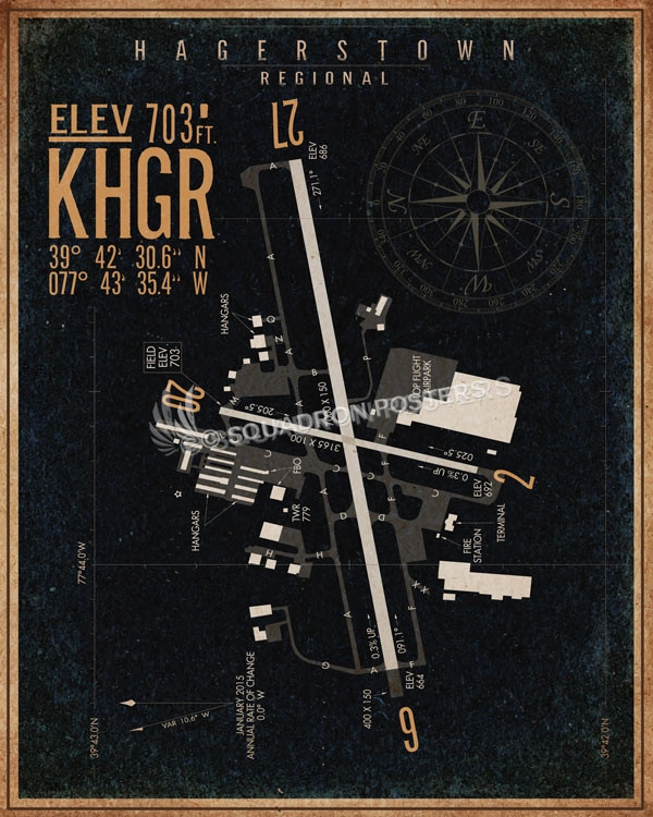
Hagerstown Regional Airport (IATA: HGR, ICAO: KHGR, FAA LID: HGR), also known as Richard A. Henson Field, is a county-owned public-use airport in Washington County, Maryland, United States. It is located four nautical miles (5 mi, 7 km) north of the central business district of Hagerstown, Maryland, about a half mile (800 m) from the Maryland/Pennsylvania border. The airport is in Western Maryland off Interstate 81 at exit 10 and U.S. Route 11, not far from Northern Virginia, South Central Pennsylvania, and the Eastern Panhandle of West Virginia. The airfield opened in 1928 on 60 acres of farmland purchased by the Kreider-Reisner Aircraft Company. It was purchased by the City of Hagerstown in 1933. The facility was named Washington County Regional Airport in 1981, when ownership was transferred from the City of Hagerstown to Washington County. In 1998, the county renamed it Hagerstown Regional Airport – Richard A. Henson Field.
Massive 40×60 canvas wraps and framed canvas wraps available upon request!
“Hagerstown Regional Airport KHGR Airfield Map Art” by – Squadron Posters!
Squadron Posters offers the world’s largest collection of Squadron Specific Art! Check out our stunning vintage style military aviation themed travel posters, honoring All Branches of Service. Our artwork not only represents aircraft, armored cavalry, or ships, it represents adventure and travel. This means we create posters featuring the Space Needle, New Orleans, the Golden Gate Bridge, Mt Rushmore and the National Mall. Of course, McChord AFB isn’t in Seattle but if you’re stationed there your adventure surely involves the Space Needle!
This is what makes Squadron Posters different–it’s about remembering where you’ve lived and what you’ve seen with a vintage themed travel poster. – Collect your travels and tell your story!
[description]

,e_distort:arc:100/w_3500/if_h_gt_1110/w_2500,h_700/if_end/e_outline:14,co_rgb:130600/fl_layer_apply,e_overlay,g_north,y_120/co_$background,l_text:HanleyPro-Block.otf_150:$(line2)/w_3500//if_h_gt_530/h_530,w_2000/if_end/e_outline:14,co_rgb:130600/fl_layer_apply,e_overlay,g_south,y_410/co_rgb:110500,l_text:HanleyRough-Script.otf_250:$(line3)/fl_layer_apply,g_south,y_120/c_scale,h_2300,l_$patch1/y_-150,e_overlay,fl_layer_apply/c_scale,h_2300,l_$patch1/y_-150,e_contrast:50,o_20,fl_layer_apply/l_leather:leathgrunge3/fl_cutter.layer_apply/u_leather:brownjacket2.jpg/bo_500px_solid_rgb:582811///t_brownpatchfeat///leather/brownjacket2.jpg "Leather Bomber Jacket Style Art")
")


